NASA announced Tuesday that its CALIPSO satellite, which takes climate, weather and air quality measurements using LIDAR, has ended its science mission.

The CALIPSO mission that analysed climate, weather, and air quality ended on August 1, National Aeronautics and Space Administration (NASA) announced Tuesday.
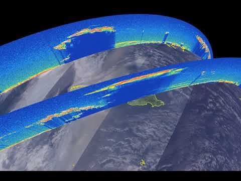
The CALIPSO (Cloud-Aerosol Lidar and Infrared Pathfinder Satellite Observation) mission recorded more than 10 billion LIDAR measurements and helped create thousands of scientific reports over its 17 years of operation. It was launched jointly by NASA and France’s CNES (Centre National d’Etudes Spatiales) along with the cloud-profiling radar system on the CloudSat satellite.

You have exhausted your
monthly limit of free stories.
To continue reading,
simply register or sign in
Continue reading with an Indian Express Premium membership.
This premium article is free for now.
Register to read more free stories and access offers from partners.
Continue reading with an Indian Express Premium membership.
This content is exclusive for our subscribers.
Subscribe now to get unlimited access to The Indian Express exclusive and premium stories.
“We had to build, for the first time, a sophisticated lidar capable of operating in space. Then we intended to fly that satellite in close formation to match the CALIPSO lidar profile measurements with the radar profile measurements from CloudSat,” Chip Trepte, NASA’s project scientist for CALIPSO, said in a press statement.
The Lidar and radar instruments on the satellite direct beams of energy at Earth and measure how they reflect off the clouds and the aerosols in the atmosphere. Other orbiting science experiments typically use passive sensors that measure the sunlight or other radiation reflected by the Earth or clouds.
Most Read

The two satellites were launched on April 28, 2003, and they circled the planet in a Sun-synchronous orbit from the North to the South poles. This meant that they crossed the equator in the early afternoon every day. They measured the altitude of clouds and layers of airborne particles like dust, sea salt, ash and soot while probing the “vertical structure” of the atmosphere.


The observations from the two satellites allowed scientists to build more sophisticated models to understand complex atmospheric processes like cloud formation, atmospheric convection, precipitation and particle transport. This was especially useful in situations like during the massive wildfires in Australia in 2020.
At that time, CALIPS observed smoke rising to between 15 and 20 kilometres above the Earth;s surface, high enough to reach the stratosphere, making them some of the highest plumes ever recorded.
© IE Online Media Services Pvt Ltd
First published on: 28-09-2023 at 1:51 PM IST