VIJAYAWADA: NTR district police launched a technology-driven initiative, ‘ASTraM’, to put an end to traffic woes in the city.
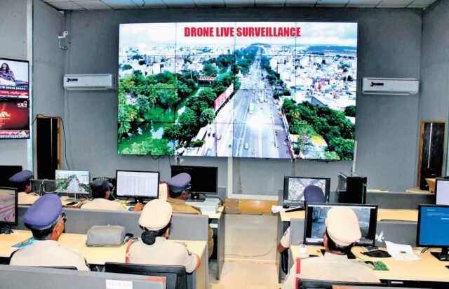
Defined as Actionable intelligence for Sustainable Traffic Management, ASTraM uses drones and integrated an command control room to send instructions to traffic police on ground to regulate traffic.
As part of the pilot project, NTR district police have collaborated with a Hyderabad-based engineering consultant Arcadis and developed the mobile application ASTraM, which primarily focuses on traffic issues.
NTR District Commissioner of Police SV Rajashekhar Babu explained that the mobile application will be used to study city patterns, rain mapping and other development activities. The data obtained will be studied thoroughly and will be used to improve the city infrastructure, he added.
Explaining the functioning of the application, the Police Commissioner said, “The app will collect information on traffic updates from Google Maps, My Maps, Ola and Uber and alert traffic personnel in real-time through WhatsApp and Telegram. This will be further assigned to ground traffic police who will reach the spot of traffic congestion and clear the traffic in less than 10 minutes. The app will let us know the length and density of vehicular traffic so that we can plan alternate routes, if the problem is bigger. A dedicated team will be monitoring the traffic movements from the operation command control room and alert ground level staff for quicker reaction.”
The pilot project has been launched at 25 identified problematic locations to study traffic patterns, predictions for alternate routes and dynamic traffic management.
“Additionally, we are improving CCTV network to monitor traffic in real-time. Analysing traffic patterns will help us provide solutions scientifically. We will also use drones to get live feed of traffic, especially on Varadhi, Prakasam Barrage, Benz Circle, Ramesh Hospital junction and Ramavarappadu Junction as the areas are more prone to traffic congestions,” Rajashekhar Babu noted.
Further, balloon drones have been deployed to study traffic congestion patterns and traffic. “The data will help us overhaul traffic management systems and see free flow of traffic in the city, especially in peak hours,” he explained.


