Visakhapatnam: In its recent ‘Authority’ meeting, the Visakhapatnam Metropolitan Region Development Authority (VMRDA) decided to prepare a master plan and perspective plan for the newly merged mandals, which span approximately 2,455 square kilometre. A master plan and a perspective plan were previously developed for the original area of 4,380 square kilometre.
With the addition of several new mandals to the VMRDA’s jurisdiction, the urban body decided to create similar plans for these newly incorporated regions. The master plan will serve as a comprehensive sectoral blueprint, addressing zoning, industrial development, and other key aspects, while the perspective plan will focus on long-term strategic goals, policies, and sector-specific strategies.
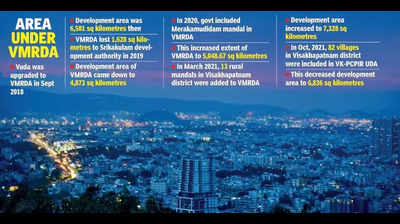
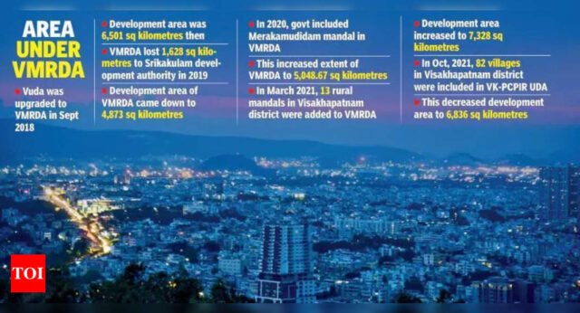
Since the replacement of the former Visakhapatnam Urban Development Authority (Vuda) in 2018, VMRDA underwent several changes in both its area and development scope. To accelerate urbanisation in the northern coastal region, state govt upgraded Vuda to VMRDA by designating a 6,501-square-kilometre development area covering the districts of Srikakulam, Vizianagaram, and Visakhapatnam.
However, in 2019, VMRDA lost a significant portion of its area—about 1,628 square kilometre in Srikakulam district—following the establishment of the newly formed Srikakulam Urban Development Authority (Suda). State govt transferred jurisdiction over the Srikakulam municipal corporation, Rajam Nagar Panchayat, Amadalavalasa municipality, and 417 villages across 11 mandals to Suda. This reduced VMRDA’s development area to 4,873 square kilometre.
In Jan 2020, state govt once again expanded VMRDA’s jurisdiction by incorporating Merakamudidam mandal in Vizianagaram district, which included 41 villages covering 17,529 hectare (or 175.29 square kilometre). This adjustment pushed VMRDA’s area beyond the 5,000 square kilometre mark, increasing it to 5,048.67 square kilometre.
In March 2021, 13 mandals in Visakhapatnam district, covering around 2,280 square kilometre, were added to the VMRDA’s jurisdiction. This expansion increased the total area to 7,328 square kilometre. The move followed a formal request from VMRDA officials to state govt, citing the rapid urbanisation in the fringes of the existing VMRDA boundaries. The letter argued that the inclusion of these areas would alleviate pressure on urban infrastructure, ensure planned development in peripheral zones, and prevent haphazard growth.
However, in Oct 2021, state govt established the Visakhapatnam-Kakinada petroleum, chemicals, and petrochemicals investment region urban development authority (VK-PCPIR UDA), replacing the former Visakhapatnam-Kakinada petroleum, chemicals, and petrochemicals investment region special development authority (VK-PCPIR SDA). As part of this restructuring, seven mandals, comprising 82 revenue villages, were excluded from the VMRDA and incorporated into the new VK-PCPIR UDA, reducing the VMRDA’s jurisdiction to 6,836 square kilometres.
Following govt’s approval of the perspective plan and master plan-2041 in 2021 for the original area of 4,380 square kilometre, the VMRDA received 115 objections and suggestions from the public regarding the realignment, deletion, and addition of roads in the master plan, as well as changes in land use. According to VMRDA officials, they are awaiting directions from state govt regarding any necessary modifications.


