
Visakhapatnam: An analysis of gridded satellite altimeter data from 1993 to 2020 estimates that sea levels in Visakhapatnam rose at a rate of approximately 4 to 4.6 mm per year. According to recent data from the Union govt, Mumbai recorded the highest sea level rise during this period, ranging from 4.4 to 4.8 mm per year. Other coastal regions that saw a rise in sea levels include Mormugao (4.1 to 4.5 mm annually), Kochi (3.9 to 4.3 mm), Chennai (4.05 to 4.6 mm), and Paradip (4.07 to 4.8 mm).
The rising sea levels, a significant consequence of climate change, signal only an impending increase in coastal inundation and erosion. Global warming is a major driver of this trend, as higher temperatures cause seawater to expand and glaciers and polar ice sheets to melt. Other contributing factors include land subsidence, shifts in ocean currents, and increased run-off from deforestation and excessive groundwater extraction.
According to the fifth assessment report from the Intergovernmental Panel on Climate Change, global sea levels rose at an average rate of 1.8 mm per year over the past century. A study conducted by the Indian National Centre for Ocean Information Services, based on satellite altimetry and model simulations, showed an alarming rise of 6.1 mm per year in the North Indian Ocean between 2003 and 2013.
Dr OSRU Bhanu Kumar, Professor Emeritus from the department of Meteorology and Oceanography at Andhra University, said climate change is a key factor in rising sea levels. “The increase in sea level will have several consequences, including coastal inundation over the decades. Human activities, thermal expansion, and factors such as upwelling and sinking are contributing to sea erosion. The chemical balance of seawater is also shifting toward greater acidification. We must focus on ways to stop or slow global warming,” said Bhanu Kumar.
The Union ministry of environment, forest, and climate change, under the integrated coastal zone management project, has demarcated the hazard line along the entire coastal belt of Andhra Pradesh. This line reflects shoreline changes, including sea level rise due to climate change, and serves as a projection of impacts over time. It is intended to be used by state agencies as a tool for disaster management, aiding in the planning of adaptive and mitigation measures for the coastal environment.
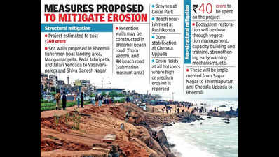
In the meantime, the National Centre for Coastal Research is providing technical support to AP govt in preparing detailed projects to mitigate sea erosion in various parts of the state. These include projects for Sriharikota and Vodalarevu (near Konaseema). An integrated coastal protection strategy will also be prepared for the Kakinada coast and Uppada to address the erosion of fishing villages and eco-sensitive areas such as the Coringa mangrove forests. Similarly, a detailed project report will be made for the confluence points of Nagavali and Vamsadhara rivers, supporting the local fishing community. A DPR for coastal erosion mitigation in Visakhapatnam was recently submitted to the National Disaster Management Authority in collaboration with the Visakhapatnam Metropolitan Region Development Authority. These proposals for Visakhapatnam are estimated to cost about Rs 200 crore.


